Hiking Around Victoria BC: Popular Day Hikes
Hiking around Victoria BC is one of the most favourite activities for people of all ages here on Southern Vancouver Island. Because of our mild and mostly snow-free winters and not-too-hot summers, it is something to be enjoyed nearly every day of the year. And the region doesn't disappoint. With short, flat options right up to challenging peaks and rough terrain, there really is something for everyone hiking around Victoria BC.
1. Thetis Lake
This is one of my favourite day hikes and one of the most popular spots for hiking around Victoria BC. I like it partly because it is close to home but mostly because of the numerous options this park offers.
One of the most popular trails with hikers and dog walkers alike is the lower Thetis trail. This trail is relatively short in length with modest elevation changes.
Throughout the park there are over 40 kms of trails with varying degrees of difficulty that are accessible year-round. Many of the trails interconnect which allows visitors to customize their hike to make it as long and as challenging as they prefer. Also for the mountain biker, there are 12 km of blue-rated, multi-use trails that opened in the fall of 2022.

According to the CRD (Capital Regional District) Thetis Lake trails are rated moderate to challenging and the park encompasses over 921 hectares. Main access to the park is via Six Mile Road in View Royal. Note that pay parking is in effect for the summer season from May 1 to September 30.
Popular Hikes at Thetis Lake
- Lewis J. Clark Trail - moderate difficulty; 1.3 km one-way
- Seymour Hill Trail - moderate difficulty; 1.2 km one-way
- Upper and Lower Lake Trail - easy to moderate difficulty; 4.8 km loop
- Trillium Trail - easy 0.9 km one-way
- Craigflower Creek Trail - moderate difficulty; 1.8 km one-way
- McKenzie Creek Trail - easy to moderate difficulty trail; 2.6 km one-way
- Scafe Hill Loop Trail - moderate to strenuous in difficulty; 4 km loop
2. Francis King Regional Park
I first visited this park with my son's scouting group and it remains one of my favourites - especially on a hot summer day. The canopy of trees drops the temperature considerably, making this an especially good park for walking with your furry friends. The park features a multitude of short trails that mostly interconnect so you can design the hike that suits you best. You can also access Thetis Lake trails via the Panhandle Trail. One of the highlights is the Elsie King Trail which is a cedar boardwalk with access for people with disabilities.

Popular Hikes at Francis King
Centennial Trail - moderate difficulty - 3km loop
Elsie King Accessible Trail - easy 800m
High Ridge Trail - trail itself is 865m; from the parking lot it is 2.8 km one-way; moderate difficulty
Panhandle Trail - connects to Thetis Lake Regional Park - moderate difficulty - 2 km one -way
Shooting Star Trail - access from Elsie King Trail or Centennial Trail - moderate 1km trail one-way
3. Royal Roads
Where can you go hiking around Victoria BC and see well-manicured and beautiful gardens? The grounds of Royal Roads University! The trails and gardens at Royal Roads are possibly one of the best-kept secrets of the region. The grounds of Royal Roads is made famous by Hatley Castle where numerous television shows and movies have been filmed including Smallville, X-Men and Deadpool. But more than just a scenic backdrop for television and film, Royal Roads has an extensive trail network with ponds and streams, open parklands, dense old-growth forest and formal gardens open to the public.

My only complaint about the trails at Royal Roads is the poor signage. It is easy to get lost (more than once!) but the terrific scenery that includes forest, ocean, creeks and waterfalls we discovered along the way was quite enjoyable.
I recommend you download a map before you head out and plan on about 1.5 hours of mostly easy to somewhat moderate terrain. You are welcome to visit year-round but spring and summer is the best time for the gardens. If you prefer, book a free orientation with Recreation Centre staff who can guide you on 3km or 10km routes.
Popular Hikes at Royal Roads
The majority of trails at Royal Roads are not named with the exception of Charlie's Trail. Charlie's Trail is a wooded trail that starts near University Drive and College Road and ends near University Drive and West Campus Road. This trail will take you along Colwood Creek, past a small waterfall, through a gully, up and down a couple sets of stairs and through a meadow.
One of the more popular hikes is around the perimeter of the grounds in a giant loop that follows a combination of dirt trails, gravel roads and some short paved sections. It will take you approximately 1.5 hours and is considered an easy route.


4. Esquimalt Lagoon
Esquimalt Lagoon is like my favourite sweater. No matter how many times I wear it, I just never get tired of it. I love this place for so many reasons and it simply never disappoints. When you think of hiking around Victoria BC you may think of trails of various terrain through thick forests - that is not what you'll find at the Esquimalt Lagoon. In fact, the "hiking" is done along a narrow path beside the bird sanctuary, on the pavement of Lagoon Road or on the gravelly sand of the beach.

Some may not even consider the Lagoon to be a hike but I do, which is why it has made my list.
My normal hike here is to park my vehicle at one end and walk to the other and return. It is approximately 2 km from one end of Lagoon Road to the other. Read more about Esquimalt Lagoon here.
5. Cedar Hill Golf Course Trail
As the name implies, this hike follows the perimeter of the Cedar Hill Golf Course in Saanich. It is a 3.6 km chipped bark trail loop that is somewhat hilly in sections (elevation gain is 60m) but is still considered an easy hike. Highlights of this trail are the two small lakes you pass that are popular with birdwatchers along with scenic views of Victoria and the Juan de Fuca Strait from the higher elevations.
Parking is available in either the Cedar Hill Rec Centre or the Cedar Hill Golf Course lots.
6. Elk and Beaver Lake
No list for hiking around Victoria BC could omit the trails of Elk and Beaver Lake. Based on my personal experience (and the size and busyness of the parking lots), this has got to be the most popular spot for hiking around Victoria. The 443 hectare park located in Saanich is also enjoyed for jogging, swimming, picnics, paddling, rowing, fishing, cycling, equestrians and more. The trail that loops around the perimeter of both fresh-water lakes is 10km in distance (with distance markers) and can take up to 2.5 hours depending on your speed and endurance. There are shorter trails and you can also do an in and out if you prefer.

To access the trail, there are several parking lots around the perimeter of the two lakes with the main lots being at Beaver Beach off Elk Lake Road and at Hamsterly Beach just off the Pat Bay Highway. There is a nature centre at Beaver Beach open Fridays and Saturdays in July and August with parks staff and volunteer naturalists who can answer your questions and point you in the right direction on the trails.
7. Swan Lake and Christmas Hill
Although the hikes at Swan Lake and Christmas Hill are often lumped together, they are in fact 2 very different hikes and can be done together or separately. The hike around Swan Lake is an 2,5 km loop on a trail that is partly bark chip/gravel trail and partly boardwalks above the marshlands and fields. It is a bird-watchers paradise! The views and serenity of Swan Lake make it a peaceful, easy hike.

The trail to Christmas Hill however offers a bit more of a challenge with some steep and rocky sections and climbing to 109 meters above sea level. Your reward is the spectacular views of Victoria, along with seasonal wildflowers.
8. Mount Douglas
If you want to experience some of the best hiking around Victoria BC, then add the trails of Mount Douglas Park in Saanich to your list. With varying levels of difficulty (from easy to strenuous), and varying lengths - there is a hike for everyone. The largest park in Saanich boasts 21 kms of trails/walking paths along beach, through fir, cedar and Garry Oak forests and culminating in a 360 degree view of the Saanich Peninsula, Greater Victoria and the Juan de Fuca Strait. (Note not all trails lead to the summit but if you keep climbing up, you'll get there eventually).

The trails intersect throughout the park, making it easy to add additional distance to your hike. However, not all the junctions are well marked. I recommend carrying an up-to-date map with you - however on my most recent visit, my group got somewhat off-course even with a map! We just ended up adding a few extra steps we weren't counting on!
Popular Hikes at Mount Doug Park
The trails at Mount Doug are classified as green (easy), blue (moderate) and black (difficult). Several of the trails start off with one level of difficulty but may become increasingly or decreasingly more difficult as you continue. Note to reach the summit, you will have to hike on green, blue and black trails.
- Whittaker - green/blue - a 3.8 km loop, this is one of the longest and most popular trails in the park. It winds completely around the base of the mountain through a variety of foliage with rolling terrain but nothing too strenuous. This is my personal favourite trail in the park. This trail takes about 2 hours to complete.
- Norn - blue - a moderately difficult 1.7 km one-way trail accessed via the Whittaker, Merriman or Irvine trails. This trail does not reach the summit.
- Merriman - blue - a moderately difficult 1.3 one-way trail. The Merriman trail is accessed via the Whittaker trail on both ends. It does not reach the summit but rather traverses at approximately the mid-level section of the mountain.
- Irvine - blue/black - about 1.6 km one-way. This trail leads directly to the summit through some rugged terrain that can be slippery at times. Depending on your fitness level, allow up to 2 hours to reach the summit.
- South Ridge - black/blue - Access the South Ridge trail from the Harrop trail. This moderate to difficult short section will lead to the summit.
- Blenkinsop - black - a short but strenuous hike of approximately 600 metres that intersects with the Tod Trail. To continue your hike, continue on the difficult-rated Tod Trail until you reach either the Whittaker trail (moderate-rated section) or the Little Mount Douglas trail which is another difficult level trail.
Other trails at the park include:
- Mercer - green
- Maddock - green
- Churchill - green/blue
- Douglas - green/blue
- Harrop - blue
- Tod - black
- Glendenning - black
9. Galloping Goose Regional Trail
The Galloping Goose Regional trail is a 55km former railroad multi-use trail that moves from downtown Victoria to Sooke through urban, suburban and forested areas. The Goose, as it is affectionately known, is the most accessible trail for hiking around Victoria BC. It intersects with the Lochside Trail at Uptown which enables users to travel out to Sidney on a mostly protected path (there are sections that follow roadways). There is also an intersection to the E&N Trail in View Royal that traverses through View Royal and Esquimalt. Many people refer to this entire network as the Galloping Goose and frankly it is easy to see why. You can easily transfer from one trail to the other and not even realize it - especially at the Lochside intersection at Uptown.
The Goose can be accessed on foot or bicycle from multiple spots along the way. There are also several parking lots for those who need to travel to the trail.
Access parking for the Galloping Goose Regional Trail at these locations:
- Atkins Road
- Aldeane Avenue
- Page Avenue
- Marwood Avenue (Luxton Fairgrounds)
- Rocky Point Road
- Roche Cove
- Ludlow Road
- Sooke River Road
- Sooke Potholes
Refer to the trail map for details.
The trail is paved through most of the city but changes to gravel near Goldstream Avenue. There are several road crossings until you reach the more rural sections of the trail in Metchosin. As it is a multi-use trail, expect to see hikers, joggers, cyclists and in the rural sections, equestrian use. From my experience, most people who choose to hike on this trail, do so in the rural areas of Metchosin and East Sooke (although the 300 metre Selkirk Trestle near downtown Victoria is a spectacular highlight). The rural sections of the trail provide some of the best hiking around Victoria BC for those who want to experience our natural beauty deep in the woods but like the security of a wide, well-used, fairly flat path. You are advised to remain alert and aware of wildlife in the area.
The Galloping Goose Regional Trail is part of the Trans-Canada Trail, a coast-to-coast multi-use corridor that connects regional trails across the country.
10. Lochside Regional Trail
As mentioned above, the Lochside Regional Trail connects to the Galloping Goose Regional Trail at Uptown and travels up the Saanich Peninsula to Sidney. It is heavily used by commuters on bicycles so I personally recommend hiking on this trail during the workday if possible or on weekends, although it can be even more busy on weekends but usually with a predominance of strollers and families, not speeding commuters!
Lochside is a 29 km one-way multi-use trail, including equestrian use in the rural sections. It is mostly pavement in the urban areas and transitioning to gravel or dirt in the agricultural areas, which can be quite muddy in spring or following heavy rains.
The trail follows old rail lines so the path remains relatively flat. My favourite section is traversing the wetlands at Swan Lake and the Swan and Blenkinsop trestles. Be aware these can be slippery when wet or frosty.
The trail does have several road crossings as it heads out of the city and is mostly well marked however I personally found the signage in the Lochside Drive and Cedar Hill Cross Road area to lacking. I ended up on Lochside Drive and followed it along for a block or two before I came to some trail parking and got back on the right path.
11. Matheson Lake
The trail around Matheson Lake is a scenic, moderately difficult 3.8 km loop. I dragged my husband out to this hike a while back and we quickly discovered it exceeded our abilities at the time - hubby was sure I was trying to kill him! But we made it and were so proud of ourselves. The trail follows the perimeter of the lake with a very short section along the Galloping Goose Trail. The inclines are generally not steep, but there are continuous hilly sections that can seem relentless for the less-fit hiker. Be sure to avoid any trails that lead away from the lake.
In addition to hiking, the lake is popular for swimming, fishing, kayaking and stand up paddling.
Depending on your fitness level and interest, there are many more good locations but these are my favourite spots for hiking around Victoria BC. See you on the trails!
Recent Articles
-
Where to Stay in Victoria, BC: A Comprehensive Guide
Jul 10, 24 12:42 PM
 Choosing the right place to stay can significantly enhance your experience. This guide provides tips and ideas to help you decide where to stay in Victoria.
 -
Best Hotels in Downtown Victoria: My Top 10 Picks
Jul 09, 24 06:08 PM
 Don’t risk being disappointed with your accommodations. Get trusted information about the 10 best hotels in downtown Victoria from a verified local.
 -
Horse Drawn Carriage Rides in Victoria BC: A Journey Through Time
Jun 08, 24 01:38 AM
 Experience the beauty and heritage of Victoria BC through a horse drawn carriage ride.


Recent Articles
-
Where to Stay in Victoria, BC: A Comprehensive Guide
Jul 10, 24 12:42 PM
Choosing the right place to stay can significantly enhance your experience. This guide provides tips and ideas to help you decide where to stay in Victoria. -
Best Hotels in Downtown Victoria: My Top 10 Picks
Jul 09, 24 06:08 PM
Don’t risk being disappointed with your accommodations. Get trusted information about the 10 best hotels in downtown Victoria from a verified local. -
Horse Drawn Carriage Rides in Victoria BC: A Journey Through Time
Jun 08, 24 01:38 AM
Experience the beauty and heritage of Victoria BC through a horse drawn carriage ride.
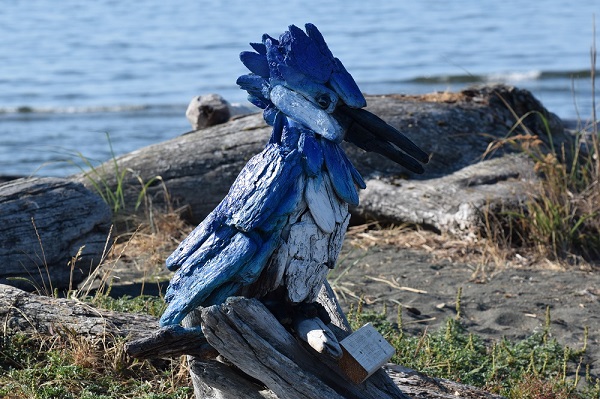
Discover the beach art at Esquimalt Lagoon.